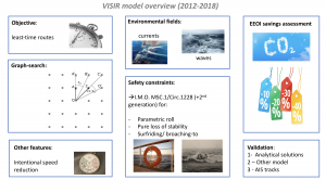
VISIR, developed at CMCC since 2012, is a numerical model designed for calculating optimal maritime routes. Utilising a graph-search methodology, VISIR incorporates dynamic meteo-oceanographic fields as input for its computations. VISIR is a registered trade mark at EUIPO. So far, two related yet distinct VISIR models exist: VISIR-1 and VISIR-2.
VISIR-2
VISIR-2 is coded in Python. It was first released in 2023.
For an introduction, please have a look at this presentation.
For download, go to its zenodo repository. A cold-start guide to the software installation is available here.
VISIR-1
VISIR-1 is coded in Matlab®. VISIR-1 was released in two versions: VISIR-1.a (in 2016) and VISIR-1.b (in 2019).
VISIR-1 routes were validated versus both analytical solutions, another path planning model, and actually sailed tracks reported through AIS data. Furthermore, VISIR-1 considers both static constraints, such as avoidance of shallow waters, as well as time-dependent constraints related to vessel intact stability.
Input
VISIR-1 employs significant wave height, wave spectrum peak period, wave direction, and ocean surface current fields.
Output
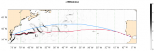
VISIR-1 computes two types of tracks: geodetic and optimal. The geodetic track is the straightest path between departure and arrival location given the coast topology and the bathymetry. The optimal track is the shortest path taking also into account the time-dependent sea-state and sea circulation and a few vessel stability constraints.
An Example In figure below, geodetic (blue) and optimal tracks (red) for the Norfolk-Algeciras route accounting for both surface gravity waves and currents. Ocean current magnitude is displayed as shading and its direction as white arrows. Vertical panel stripes refer to daily timesteps of the optimal tracks – the interface between stripes is marked by a green dashed line. Departure date: 2018-06-21..